
Some 700,000 drones are projected to hit the skies above the U.S. this year, according to the National Aeronautics and Space Administration (NASA). The independent agency of the United States Federal Government responsible for the civilian space program, as well as aeronautics and aerospace research wants to keep drones from crashing into each other or other aircraft. It’s a growing challenge NASA is trying to tackle using digital technologies, including wireless networks, cloud computing and artificial intelligence.
Whether they’re monitoring crops, delivering food, scanning traffic, or filming backyard barbecues, drones (unmanned aircraft systems, or UAS) make up an entirely new class of air traffic. One that NASA claims is quickly outgrowing the capacity of existing air traffic control (ATC) systems.
“The current way the FAA regulates and manages manned aircraft – individual air traffic controllers interacting with individual pilots – just won’t scale up,” said Ron Johnson, project manager of NASA’s Ames Research Center’s Unmanned Aircraft System (UAS) Traffic Management project.
“How is all this traffic inserted into existing national airspace going to be managed safely?”

A multi-year NASA project has been working towards creating a UAS Traffic Management (UTM) system that connects drone pilots with each other and government entities, from local law enforcement to the Federal Aviation Administration (FAA). Drone technologies such as cameras, radar, and LIDAR, are being tested in combination with existing cell phone and Wi-Fi networks. The basic idea, Johnson explained, is less like the current top-down ATC system and more like an aerial version of the driving navigation app Waze, where everyone knows where every device is, or is planning to go, and the entire network is continuously updated with data on changing conditions and potential hazards.
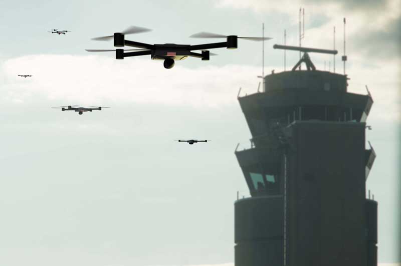
Four phases of research started in 2015, focused on drones under 55 lbs and flying below 400 feet, and gradually progressing from rural to city environments. A variety of field tests looked at challenges such as navigating geofencing, avoiding other drones, and flying beyond visual line-of-sight.
“The main part of the system is developing software to evaluate and approve flight plans,” Johnson said. “If a vehicle leaves a planned route, then the system communicates to other drones in the area: there’s a rogue drone, take action.”
The UTM software is hosted on Amazon Web Services cloud servers.
The final phase of testing came in summer 2019, with two-week flight tests in Reno, Nevada and Corpus Christi, Texas. Johnson said urban environments are the most challenging for both pilots and traffic control systems because there are large populations, more obstacles, fewer landing locations and more unique weather patterns.
With the help of city officials, commercial drone manufacturers, and partner organizations like the Nevada Institute for Autonomous Systems and Lone Star UAS Center of Excellence & Innovation, NASA set up five highly scripted scenarios.
“They’re a day in the life of a drone,” said Johnson.
They were done in areas that were blocked off to foot and car traffic. Alone or in pairs, drones controlled by certified pilots took off from streets and parking lots and zipped between buildings.

Successfully navigating a prescribed flight path was just step one. The real trials came with the introduction of simulated anomalies like a weather front that required all aircraft to land or return to a launch point, or events like an outdoor concert that drew increased aerial traffic.
In each case, the UTM system had to communicate with every device as it monitored changing flight paths. One scenario, a simulation of a fire breaking out, forced non-emergency drones to clear out of a specific volume of airspace so a fire department could bring its own aircraft.
Johnson calls the tests an overall success, especially in demonstrating that this kind of UTM system can be scaled up.
“Using the cloud platform for computations and communication was very successful, no hiccups there,” he said. “That’s very encouraging.”

The tests showed that the technology and reliability of the aircraft themselves is still a major hurdle.
“A lot of vehicles are being made by companies that don’t have history in aviation,” Johnson said. “These vehicles are not as safe as Cessnas or 737s.”
Reliable local communication systems are also critical. Since the traffic control system depends on instant and continuous data transfer, there’s no leeway for radio interference, Wifi clutter, or dropped cell signals. In one example, GPS signals bouncing off a tall building gave inaccurate location data.
“Those things can’t be tolerated,” Johnson said.
NASA is in the process of compiling the research results and transferring them to the FAA for implementation. Other issues that still need work include how to identify individual vehicles accurately. NASA also needs to develop detect-and-avoid systems that are reliable and small enough to fit on a drone.
A dependable system for beyond-line-of-sight flying is key to developing fully autonomous drones, Johnson said. But there are promising developments. Last December, a Dutch team won $1 million when their autonomous drone took first prize in the Lockheed Martin AI Drone Racing Innovation Challenge. NASA is currently researching pilotless vehicles large enough to carry people on short hops in urban areas, as are companies like Uber Elevate and Boeing.
In the meantime, Johnson said, “the challenge is now integrating drones flying higher, closer to manned aircraft.”
The FAA is looking at the UMT model as part of its Next Generation Air Transportation System, an ongoing overhaul and modernization of the country’s increasingly overloaded ATC network, Johnson says.
“The big dream is to integrate everything into one interoperable system,” he said.

Julian Smith is a contributing writer.
© 2020 Nutanix, Inc. All rights reserved. For additional legal information, please go here.